|
The history of DEMO: An experiment in regeneration harvest of northwestern forest ecosystems. Northwest Science 73:3-11.
|
Accepted articles and Notes
Northwest Science 97(4)
Assessing the efficacy of a large-scale habitat conservation plan in western Washington, USA - Joshua S. Halofsky, Daniel C. Donato
Habitat conservation plans (HCPs) under the US Endangered Species Act have become an important conservation tool. For over two decades, the Washington State Department of Natural Resources (WDNR) has managed much of the State’s forested lands under one of the largest and longest-running single-entity HCPs in existence, seeking to integrate timber harvest and other social-ecological values mostly related to structurally complex, older forest habitats. Here, we examine trends in older forest conditions on western Washington WDNR-managed lands relative to HCP expectations, using publicly available spatial datasets to compare trends in older forest area and connectivity before (1986-1999) and after (1999-2017) HCP implementation. Trends in both attributes changed markedly between the pre- and post-implementation periods, varying strongly with management intensity. Since 1999, total older forest area (i.e., that meeting structural index/indicator thresholds) saw little net change (-38 ha·yr-1, totaling -685 ha) across ~624,000 ha, but shifted spatially from WDNR’s most intensively managed lands (-843 ha·yr-1) to conservation-designated lands such as riparian (+552 ha·yr-1) and mixed (with both harvest and habitat objectives) upland (+253 ha·yr-1) areas. Similarly, older forest connectivity declined on lands primarily managed for timber but increased on all other lands managed less intensively. So far, the decades since HCP implementation largely have been a time of landscape reorganization – positioning the landscape consistent with HCP intentions to meet timber objectives while developing older forest habitat in designated areas into the future. This work illustrates a method to evaluate policy implementation and the likelihood of achieving HCP expectations over time.
Elevational distributions of forest floor mosses and a test of competition at two elevations in western Oregon - Bruce McCune, Jeff Diez, Joseph LaManna, Matthew G. Betts
Factors controlling mosses on the forest floor in western North America are poorly understood. We examined elevational distributions for six of the most abundant large forest floor mosses; based on those distributions, a transplant experiment of two species evaluated if interspecific interactions can be mediated by climatic context. Mosses had species-specific elevational profiles, with Rhytidiopsis robusta more prominent at higher elevations, while Hylocomium splendens, Kindbergia oregana, Rhytidiadelphus loreus, and Rhytidiadelphus triquetrus, were more prominent at lower elevations. Homalothecium megaptilum was bimodal, peaking at middle and low elevations. We selected Rhytidiadelphus triquetrus and Rhytidiopsis for a transplant experiment, because each is prominent at different elevations and they are similar in stature. Moss mat squares cut from the forest floor at middle elevations were transplanted in single- or mixed-species pattern at two sites, one high and one low. We recorded changes in percent cover within the squares over one year as well as outgrowth onto bare soil and litter. Hypothesized relative species performances based on elevational distributions were mostly not supported. The low-elevation associated species (Rhytidiadelphus) outperformed the high-elevation species (Rhytidiopsis) at the high-elevation site, both in mixture and as monocultures. At the lower site, Rhytidiadelphus grew well in mixture, but the monocultures declined. Furthermore, Rhytidiopsis grew faster at low elevation than high, both in mixture and in monoculture, despite being more abundant at high elevations. Poor performance of both species at high elevations raises interesting questions about what factors limit moss mats in general at higher elevations in the Cascade Range.
Factors influencing lake surface temperature and its trend analysis for reservoirs of the Columbia River Basin - Sanchit Minocha, Pei-Hsin Wang, Shahzaib Khan, Faisal Hossain
Lake surface temperature (LST) is one of the key indicators required for ecological and hydrological studies and for water quality management. Satellite remote sensing of LST has high spatial and temporal coverage and can be a cost-effective method of monitoring lakes. This study explores geophysical factors that control LST. LST for one hundred and fifteen reservoirs in the Columbia River basin were studied from 2000-2022. The climatic factors like air temperature, vapor pressure deficit and surface specific humidity were found to be drivers that can explain up to 80% of the variability observed in LST. Precipitation, wind speed, wind direction, and lake bathymetry along with the lake’s elevation appeared to have negligible influence on the temporal variability of LST for these Columbia basin reservoirs. Our study revealed that there is an overall increasing trend in LST. Surfaces of two-third (66%) reservoirs are warming up with a mean rate of 0.25 oC/decade while the remaining reservoirs are cooling with mean yearly trend of 0.16 oC/decade. The surfaces of reservoirs with smaller surface area and located at low elevations were found to be warming fastest whereas the surfaces of those reservoirs at higher elevation have cooling trend, especially if they have large surface area. The trend of LST of a reservoir was found to be insensitive to the depth of these reservoirs. Using the vantage of space and multi-decadal observations, this study presents a thorough overview of the thermal behavior of reservoir water surface in the Columbia River basin. The findings can build clear pathways to improving hydro-ecological studies and water management of the region that is drought prone and impacted by climate change.
The complete pre-print version of this article is available here. Below (Figure 12), an image of lake surface temperatures shows a trend of summer warming and fall cooling in low elevation reservoirs, but fall warming in high elevation reservoirs.

Creating an endangered subspecies: a comment on Smith et al. (2024) - Antoinette J. Piaggio, James R. Heffelfinger, Paul M. Meyers, Matthew W. Hopken
Smith et al. (2024) create a new subspecies of white-tailed deer (Odocoileus virginianus) occupying Douglas County, Oregon. The authors should be commended for assembling all available information on the Columbian white-tailed deer (O. v. leucurus) to support their argument, unfortunately the authors interpretation of the data is not compelling nor entirely accurate. Their justification for subspecific distinction is based on: 1) a misinterpretation or exclusion of relevant genetic analyses (Hopken et al. 2015; Piaggio et al. 2016; Piaggio and Taylor 2022), 2) an untenable definition of subspecies based on those genetic analyses and on clinal skull morphology of three small, isolated, and fragmented sampling localities.
The complete pre-print version of this article is available here. Below (Figure 1, obtained with permissions from Hopken et al., 2015), a median-joining network for the mitochondrial DNA control region from Odocoileus virginianus at sites in the Pacific Northwest. In this image, each circle (whose size is proportional to frequency within the sample, and color and pattern represent particular sampling locations) represents one haplotype, with the branch in between representing one base pair change.

Northwest Science 97(3)
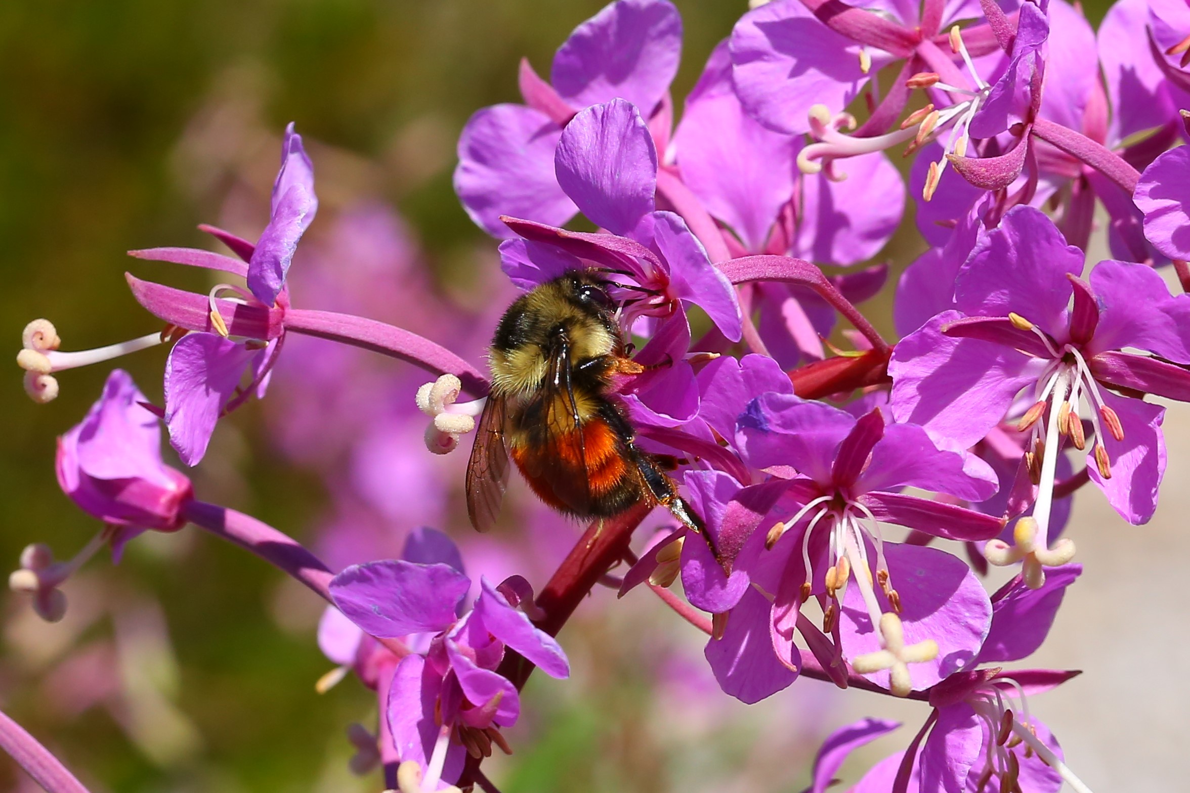
Flower phenology, bumble bee foraging, and climate change in North Cascades mountain meadows - James R. Davis, T. Abe Lloyd, Anu Singh-Cundy
We conducted a five-year study (2015-2019) of flower phenology and insect flower-foraging in Heather Meadows in the northern portion of the North Cascades in Washington State. We recorded 70 species of eudicot forbs and shrubs on seven transects at elevations ranging from 1,260 meters to 1,582 meters. In a typical year, there was continuity of floral resources within each transect and across the elevational gradient for the duration of the growing season. Black huckleberry was a critically important forage resource for post-diapause queens as they established nests in spring, even as 98% of the meadow was under snow. Transects with the highest tree island cover had the largest number of foraging spring queens. The exceptionally early spring of 2015 made it a good analog of climate change predicted for this region toward the end of the century. In 2015, flowering was two to eight weeks early for a majority of species, while the duration of flowering increased for a few species and decreased substantially for others, leading to phenological reassembly. These findings preview the potential impacts of climate change on flowering plants and flower-foraging insects in mountain meadows in the Pacific Northwest and could help guide effective conservation.
The complete pre-print version of this article is available here. Below, Bombus melanopygus visits flowers at Heather Meadows during 2019 sampling (Figure 6a).
Resilient plant communities and increasing native forbs after wildfire in a southwestern Oregon oak shrubland - Scott R. Abella, Charles D. Schelz
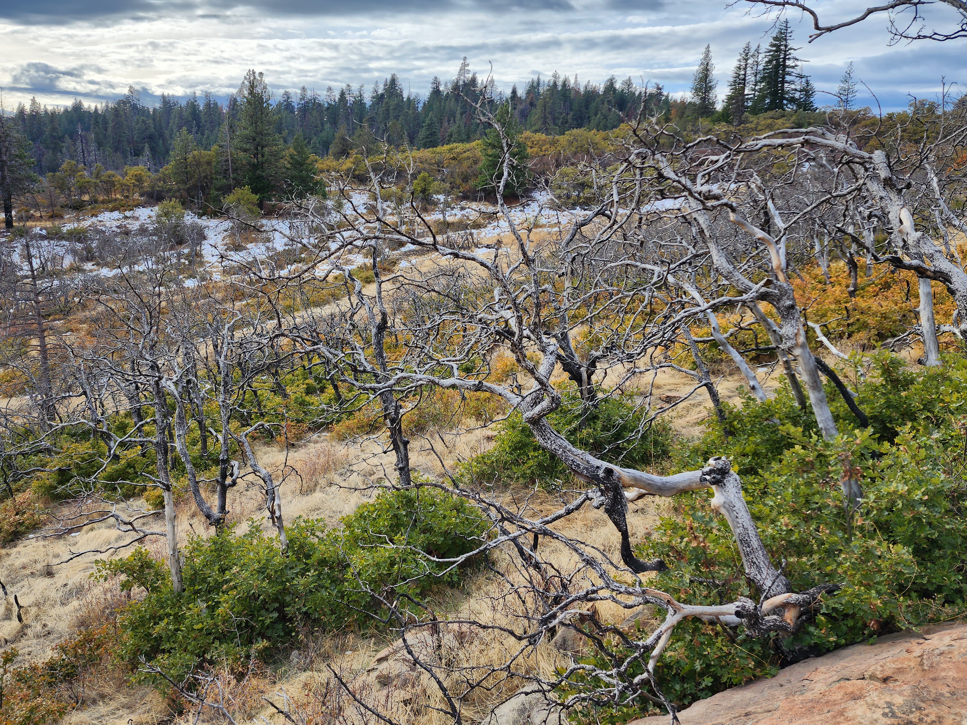
Fire ecology in oak shrublands is among the least well understood for Pacific Northwest habitats. Following the 2018 Klamathon Fire, we examined the first three years of post-wildfire plant community change and measured soil properties in shrubland dominated by shrub-form Oregon white oak (Quercus garryana) in Cascade-Siskiyou National Monument, Oregon. Based on temporal change and comparison with unburned areas, burned oak shrubland communities displayed resiliency and at least transient increases in some native plants apparently benefiting from wildfire. Via oak resprouting and other native plants increasing, total native cover rapidly recovered in burned areas by the second post-fire year to not differ (P > 0.05) from unburned areas. Native species richness (25 m2) did not differ with burning any year while community evenness and diversity were usually highest in burned areas. Native plants associated with burned areas included the perennial grass blue wildrye (Elymus glaucus), the shrub Pacific serviceberry (Amelanchier alnifolia), and most abundantly forbs, such as the perennial Scouler’s hawkweed (Hieracium scouleri) and annuals such as slender clarkia (Clarkia gracilis). Cover of non-native plants on burned areas was not higher than on unburned areas within any year. After severe burning, the 0–5 cm mineral soil had the finest texture and highest bulk density. Overall, oak shrubland vegetation displayed rapid resilience to wildfire and native forbs at least transiently increased.
The complete pre-print version of this article is available here. In the image below (Figure S1), resprouting and regrowth of vegetation in a burned oak shrubland is evident, four years after the 2018 Klamathon Fire.
Spatial and Temporal Surveys of Salmon Environmental DNA (eDNA) in a Seattle Urban Creek - Carl O. Ostberg, Chapin Pier, Dorothy M. Chase, Russell W. Perry
Seattle Public Utilities (SPU) has a history of conducting traditional fish surveys in urban streams of Seattle, Washington. Limited staff resources have reduced SPU’s capacity to monitor fish, and environmental DNA (eDNA) was recognized as an alternative survey method that could potentially improve the efficiency and capacity of SPU-sponsored fish surveys. We performed spatiotemporal surveys of eDNA to assess occupancy and distribution of Chinook Salmon (Oncorhynchus tshawytscha), Coho Salmon (O. kisutch), and Coastal Cutthroat Trout (O. clarkii clarkii) in Thornton Creek, Seattle, between October 2018 and December 2020. Peak Chinook and Coho eDNA detections occurred October and October-November, respectively, coinciding with expected adult return time. Chinook and Coho eDNA was detected in May at the time when juveniles outmigrate through the Lake Washington basin. Coastal Cutthroat Trout eDNA was widespread and detected at high rates across seasons, reflecting their ubiquitous distribution. Multiscale occupancy modeling suggested that distance upstream may have affected site-level occupancy probabilities for adult Chinook, but not Coho, that the probability of Coho and Chinook eDNA occurring in water samples was possibly influenced by survey year, and that the probability of detecting Chinook eDNA in PCR technical replicates was possibly affected by survey year and collection day but the probability of detecting Coho eDNA was only affected by day. This study indicates eDNA surveys are effective for assessing distribution and occupancy of salmonids in Seattle’s urban streams. Integrating eDNA surveys into urban stream monitoring programs can help alleviate the burden of limited resources facing many resource managers.
The complete pre-print version of this article is available here.
Evaluating abiotic and biotic predictors of coastal giant salamander (Dicamptodon tenebrosus) populations in fish-bearing headwaters of the Oregon Coast Range - Nathaniel G. Neal, Ashley M. Sanders, Ashley A. Coble, Dana R. Warren
From British Columbia to northern California, coastal giant salamanders (Dicamptodon tenebrosus) are a dominant vertebrate predator in forested headwater streams. Though widespread, body condition and abundance of coastal giant salamanders can differ substantially among locations, provoking the question of which factors may influence this variation and to what degree habitat features versus biotic variables drive variability. In this study, we collected data on coastal giant salamander populations along with four biotic factors and eight abiotic factors across 24 different study streams adjacent to mature second-growth forests in western Oregon, USA. We used single and multi-parameter linear mixed-effects models to explore the factors individually and in combination to functionally represent alternative hypotheses accounting for variation in salamander biomass density, population density, and condition. We established a set of 25 models and employed Akaike’s Information Criterion (AIC) selection for comparison. We expected food resources and the abundance of coastal giant salamander competitors to have comparable and complementary influences with stream habitat metrics. However, biotic metrics did not appear in our top models. Two abiotic variables, pool area and substrate size, best predicted the biomass and population density of coastal giant salamanders across our study streams. Substrate size and pool area were negatively related to salamander density, in contrast to our expectations. Overall, our results suggest that habitat metrics in summer months influence the abundance and biomass density of coastal giant salamanders in western headwater streams, and therefore habitat availability warrants particular consideration in conservation efforts.
The complete pre-print version of this article is available here.
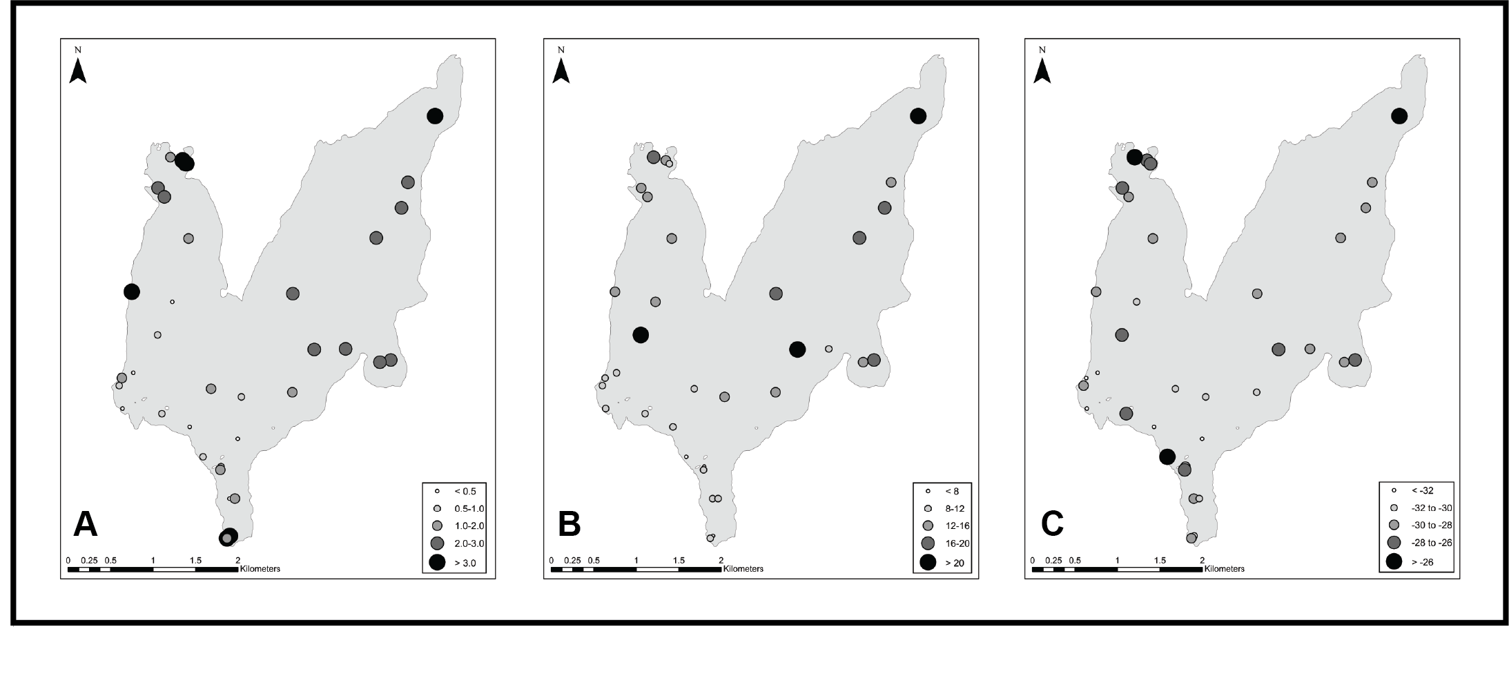
Contribution of log mat periphyton to benthic productivity at Spirit Lake, Mount St. Helens National Volcanic Monument, WA, USA - Avery Shinneman, Kena Fox-Dobbs, Emma Sevier, Angelica Luchetto, Jeremy Davis, James E. Gawel
Spirit Lake, in southwest Washington, USA, was dramatically changed as a result of the 1980 eruption of Mount St. Helens. The lake morphology was altered by debris flows and the water was sterilized of most living organisms. Trees felled by the lateral blast and subsequently washed into the lake comprise a floating log mat which now covers 20% of the lake’s surface area, providing a novel substrate for benthic productivity. By investigating the evolution of this volcanic landscape’s rapidly recovering aquatic ecosystem, our work specifically addresses the following questions related to the role of the floating log mat and associated benthic periphyton to sedimentary inputs of organic material: (1) Do patterns of log mat occupancy and related deposition of benthic periphyton correlate to spatial variation in organic sedimentary inputs? (2) How has benthic productivity changed over the lake’s 40-year history since the initial establishment of the log mat? To address these questions we analyzed biological and geochemical data derived from sampling the floating logs, sediment traps in the water column, a set of shallow sediment samples, and two sediment cores in areas of differing log mat occupancy. We used carbon and nitrogen elemental concentrations and stable isotope values of sediment organics to estimate the relative contributions of organic source materials (phytoplankton, macrophytes, periphyton) and diatom assemblages to infer information about changes through time. We found that spatial trends in sources of sediment organics corresponded to patterns of floating log mat occupancy, with higher contributions of periphyton derived biomass in areas with more frequent log presence. These results provide insight into the dynamic role of logmat-derived productivity in the ongoing recovery and evolution of the Spirit Lake ecosystem. Our findings also underscore the importance of understanding and managing coarse woody debris in oligotrophic lakes as a substrate for benthic primary productivity that supports the whole lake ecosystem.
The complete pre-print version of this article is available here. In the image below (Figure 2), surface sediment organic elemental and isotopic values - A: weight %C; B: weight %C:N ratio; C: δ13C value - are displayed for sampling locations across Spirit Lake.
Range extension of the non-native northern crayfish Faxonius virilis (Hagen, 1870) (Decapoda: Cambaridae) to British Columbia, Canada - Iain D. Phillips
Here I report the expansion of the northern crayfish Faxonius virilis (Hagen, 1870) (Decapoda: Cambaridae) into the Kootenay River Basin in southeastern British Columbia. Observation of this crayfish occurred in late summer 2023 at Moyie Lake, British Columbia based on active search collections from the littoral areas of the north end of the lake. I recorded 12 F. virilis individuals in only a few minutes of search, and they appear to be well established in the lake. As this region has been identified as having high invasion potential and risk for impact, further research on its current range in the area and effects on the local ecosystem will be important directions for further conservation work.
The complete pre-print version of this article is available here.