Northwest Science - Accepted Articles and Notes
Northwest Science 99(3)
Evaluating methods of detection for an elusive mesocarnivore in the Oregon Cascades - Marwa Mahmoud, Kalysta Adkins, Jade Keehn, Daniel Thornton
Mesocarnivores play fundamental roles in ecosystems. Yet in remote areas with difficult or limited access, many mesocarnivores can be challenging to study. The Sierra Nevada red fox (SNRF) is an elusive mesocarnivore and subspecies of red fox that is native to the Sierra Nevada mountains of California and Cascade mountains of Oregon and California and is listed as an endangered distinct population segment in the Sierra Nevada portion of its range. Little is known about the extent of SNRF distribution in Oregon and there has been a lack of systematic survey effort to effectively detect the species. We assess the effectiveness of two techniques for generating broad-scale information on SNRF distribution – camera traps and visual scat surveys. We focus on probability of detection within an occupancy framework as our measure of effectiveness and test the influence of several variables on detection probability for these two techniques. We conducted surveys in central Oregon, detecting red fox 118 times on cameras and 48 times from scat surveys. We found that non-lured, on-trail cameras had the highest probability of detecting SNRF. Although human performed scat surveys did not yield as many SNRF detections as on-trail camera surveys, in some cases detections were complementary to those from cameras, and when analyzed, scats can provide valuable genetic information on species identification, diet, survival, and reproduction. Considering these two techniques can be performed at the same time, we recommend that survey efforts targeting SNRF across their historical range should integrate on-trail camera and scat surveys.
Piscicolid leech infestations affect Northern Pike physiology at extreme levels - Kevin M. Fraley, William T. Samuel, Morag Clinton, Taylor Cubbage, Joseph Spencer
Recreational anglers noted abnormally high numbers of fish leeches (Piscicolidae) attached to Northern Pike at a shallow lake in Interior Alaska, anecdotally related to reduction in habitat availability during winter months. In response, we examined forty-two pike caught through the ice in 2023–2024 to characterize the prevalence and intensity of leech infestation, investigate the possible association of infestation with fish condition, and explore possible connections between leech load and contaminants that could impact fish immune response. Typical numbers of leeches found on fish in nearby water bodies are < 10 per individual. However, we found Northern Pike with as many as 481 leeches, commonly attached to their skin, gills, mouth, and fins. This represents the most intense infestation of fish leeches ever recorded in wild freshwater fish. Qualitatively, pike carrying high numbers of leeches exhibited serious damage to the skin. Lipid content estimates indicated that pike body condition was negatively associated with leech load when infested by more than two leeches per cm of fish length. There appears to be no link between contaminants and leech infestation, although 27 % of pike from the lake contained levels of total mercury warranting a 16 meal/month fish consumption recommendation for sensitive populations. The effects of very high leech loads on the physiology, reproductive potential, and survival of individual pike are likely negative, and warrant future study. Overall, this investigation represents important documentation of a potential stressor to high latitude fishes, as well as data for comparison in scenarios where climate change or anthropogenic impacts affect parasite-host dynamics.
The complete pre-print version of this article is available here.
Wildfire increased stream flow and native salmonid production in Stapaloop Creek - Chris Fisher, Benjamin Briscoe, Mark Roes, Ian Courter.
Contemporary forest management practices, including fire suppression, increases tree stand density relative to historic conditions. This may lead to reduced summer baseflows as snow interception and evapotranspiration increases, which may influence native salmonid productivity. We implemented a paired watershed study in two headwater streams within a heavily wooded area in northeast Washington State. From 2014 to 2018, we measured stream discharge, physical stream habitat characteristics, and fish densities in Stapaloop and Swimptkin Creeks, neighboring subbasins within the Omak Creek watershed. Initially, we planned to mechanically reduce basal area within the Stapaloop Creek drainage prior to comparing environmental responses between the two creeks. However, during the summer of 2015, a wildfire burned over half of the Stapaloop Creek drainage at moderate to high severity. As a result, base flows in Stapaloop Creek increased 35.7% compared to Swimptkin Creek and native Rainbow Trout density responded positively, while density of non-native Eastern Brook Trout decreased. Brook Trout and Rainbow Trout densities in Stapaloop Creek returned to pre-fire levels three-years later, but streamflow remained higher compared to the control watershed. Our results suggest that largescale reduction in tree stand density can cause changes in streamflow that provide benefits to native salmonid populations where fire suppression has been practiced and timber harvest occurs infrequently. Future research should consider both native and non-native species, as well as multiple timescales, when investigating the response of fish populations and their habitat to changes in streamflow following disturbance such as wildfire and forest thinning.
The complete pre-print version of this article is available here.
Research Notes
Feeding ecology of Great Basin spadefoot tadpoles - Saac Lee, Scot Erickson, Charles R. Peterson, Ken A. Aho, Jericho C. Whiting
The diet of Great Basin spadefoot (Spea intermontana) tadpoles is poorly understood in peer-reviewed literature. We recorded feeding events of spadefoot tadpoles during > 207 hours of spadefoot surveys from May to July 2022–2024 in southeast Idaho, USA. We opportunistically recorded 69 feeding events by tadpoles on 12 different prey items (differing life stages of the same prey species were considered distinct) with a mean feeding group size of 4 (sd = 7.9) spadefoots. The most frequently observed predator/prey interaction was spadefoot tadpoles foraging on conspecific tadpoles (n = 37). We also observed spadefoot tadpoles foraging on a leech (Annelida), dragonfly larvae (Anisoptera), feces from moose (Alces alces) and coyote (Canis latrans), fish (Actinopterygii), tadpole shrimp (Triopsidae), western tiger salamander (Ambystoma mavortium) tadpoles and carcasses, boreal chorus frog (Pseudacris maculata) carcasses, and spadefoot embryos. Our study documents the diverse diet of spadefoot tadpoles, including dead and living animals and plant matter, and provides new insights into the feeding patterns of Great Basin spadefoot tadpoles.
The complete pre-print version of this article is available here.
Northwest Science 99(2)
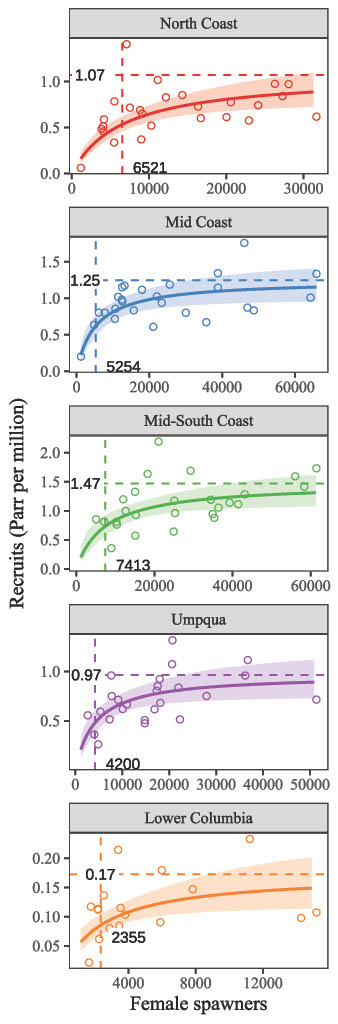
An evaluation of spawner-to-parr productivity for coho salmon in Western Oregon Evolutionarily Significant Units - Ronald J. Constable Jr., Megan C. Sabal
Coho salmon (Oncorhynchus kisutch) populations in the Western Oregon coast are culturally and economically valuable, and agencies employ conservation measures to increase freshwater productivity. The limiting factor to freshwater productivity is posited to be the capacity of the habitat to support overwinter survival, but survival rates at earlier life stages may be co-limiting and are relatively understudied. If density-dependence limits productivity at spawner-to-parr life stages, it could inform conservation efforts. We examined patterns in coho salmon parr productivity across the Oregon Coast Coho (OCC) and Lower Columbia River (LCR) Evolutionarily Significant Units (ESUs) using Oregon Plan for Salmon and Watersheds (OPSW) monitoring data. OPSW monitoring has been continuous in the OCC since 1997 and in the LCR since 2005, producing annual abundance estimates of parr and parental adults in 1st–3rd order streams on the stratum (clusters of similar populations within ESUs) scale. Using these estimates, we fit three Bayesian stock-recruit models with strata-specific parameters to evaluate evidence for density-dependence across strata at the spawner-to-parr life stage. We found the strongest evidence for the Beverton-Holt model, which provided a substantially better fit compared to the density-independent model, suggesting strong evidence for density-dependence. Density-dependent effects were variable among strata and ESUs. Rearing capacity was highest in the Mid-South Coast stratum of the OCC, while intrinsic productivity was lowest in the LCR. All strata exhibited density-dependence at spawner abundances below recovery goals, suggesting freshwater habitat conditions in 1st–3rd order streams may be limiting coho salmon recovery at this early life stage.
The complete pre-print version of this article is available here.
Figure 2, below, shows Beverton-Holt model predictions in support of density-dependence between spawner and summer parr life stages for coho salmon, plotted by strata. The dashed lines represent Rmax (estimated maximum capacity) (horizontal) and S50 (the number of spawners at half RMax) (vertical) parameters with the values in absolute abundance near the respective axis.
Nesting success of the Commodore Park Great Blue Heron colony - Michael Marsh, Linda Marsh, Deborah Jacobsen, Carol Tofle, Jonathan D. Bakker
Long-term and consistent data are necessary to understand phenomena such as the timing and success of reproduction. A Pacific Great Blue Heron (Ardea herodias fannini) colony in Seattle, Washington, was studied from 2014 to 2023. Citizen scientists observed the usage of 120 nest locations repeatedly throughout each nesting season. Between 38 and 76 nests were active in any year. Incubation began in the colony between March 6 and 22, depending on the year (mean = March 15). The start of incubation in individual nests differed strongly within years, often by multiple months. Most measured variables differed much more strongly within years than among years. Compared to nests in which incubation began later, nests that began to be used in the first half of the season experienced an average of 5 more days of incubation and 12 more days of rearing. Early nests were also significantly more likely to successfully produce chicks, though they produced the same number of chicks per successful nest as late nests. Overall, early nests produced a disproportionate number of the colony’s chicks each year (mean = 61 %). Colony chick production was driven largely by the number of nests in a year. Nest locations used in multiple years were significantly more likely to be selected early in the season and to be successful. Pacific Great Blue Herons appear to recognize differences in nest quality and to select locations with a high likelihood of success. This study also demonstrates the value of citizen science and long-term monitoring.
The complete pre-print version of this article is available here.
Spatiotemporal occurrence of eight bat species of conservation concern in cave, river, and standing water habitats - Jessica N. Call, Ken Aho, Jericho C. Whiting, Josh Grinath
Additional information is needed to document simultaneously bat spatiotemporal occurrence at caves, rivers, and standing water. We estimated simultaneous probabilities of occurrence of eight bat species of conservation concern at 14 sites in three habitat types (i.e., caves, a large river, and at ponds) from June to September in 2022 and 2023. We used acoustic data and generalized linear mixed-effects models to document bat occurrence by day of year and habitat type. Our detectors operated 1,983 detector nights. We used 5,423 nightly species occurrences, and all bat species occurred in all the habitats we sampled. Yuma myotis (Myotis yumanensis) and little brown myotis (M. lucifugus) were the only species that were in all habitat types with > 0.25 probability of occurrence. Cave-hibernating Townsend's big-eared bats (Corynorhinus townsendii) and western small-footed myotis (M. ciliolabrum) occurred predominantly at caves in summer, whereas long-distance migratory hoary bats (Lasiurus cinereus) and silver-haired bats (Lasionycteris noctivagans), as well as the little brown myotis, occurred the most at river sites. Our study indicated that bats occurred the most at caves and along a large river. With a changing climate, increasing wind-energy development, and the impending threat of white-nose syndrome in western North America, large river systems and caves may become more important to bat populations during summer. Our work provides relative spatiotemporal baselines of bat occurrence at caves, a large river, and standing water habitats to help inform bat conservation and land-use planning.
A spatial database of historical fire in westside forests of the Pacific Northwest - Aaron Zuspan, Matthew J. Reilly, Andrew G. Merschel, Constance A. Harrington, Peter D. Teensma, Glenn P. Juday, Peter Impara, Raymod J. Davis, Alan W. Dickman
Recent fire activity across forests west of the Cascade Crest in Oregon and Washington (the “westside”) has increased interest in the region’s historical fire regimes. Substantial spatial information exists describing the location, extent, and timing of historical fires in the region, but these records represent independent efforts at local-to-regional scales, with considerable variation in data resolution, methodologies, discoverability, and metadata. To address the need for a systematic dataset of historical westside fire, we compiled a spatial database of over 7,500 fire perimeters and burned areas covering 125,000 km2, sourced from 25 datasets including historical forest inventories, cohort age studies, fire atlases, and aerial photo interpretations. We provide metadata, documentation, and guidelines for applying and interpreting the database, as well as three case studies illustrating possible applications and potential limitations. While the database documents extremely large and well-known fires such as the Tillamook Burn and Yacolt Burn, it also points to the historical importance of smaller fires and patches of stand-replacing fire on the westside. The case studies demonstrate 1) historical variability in stand-replacing patch sizes during wind-driven fire events, 2) resilience to early 20th century fire along the North Santiam River of Oregon, and 3) the role of repeated fire in early seral landscape diversity in the Coast Range. By considering the strengths and weaknesses of individual sources and using multi-proxy corroboration to reduce uncertainty, this publicly available database provides opportunities for new insights into the geographic variability of historical fire regimes on the westside.
The complete pre-print version of this article is available here.
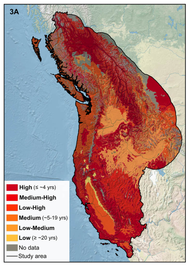
A geodatabase of historical Indigenous fire practices in the Pacific Northwest - Holly E. Reynolds, Jed O. Kaplan
Indigenous communities across the Pacific Northwest of North America (PNW) historically used fire for subsistence and cultural practices. Burning occurred across multiple seasons as fuels and weather permitted, including late winter and early spring in some regions. Regular, mixed-severity burns were applied to enhance resources, support hunting and game management, and maintain ecosystems, with these practices having the ancillary effect of reducing fuel accumulation, improving habitat, and mitigating wildfires. Fire suppression in the 20th century, including the prohibition of Indigenous burning and suppression of lightning-caused fires, resulted in widespread fire exclusion and decreased fire frequency. However, with increasing fuel accumulation, invasive species, and climate warming, fire probability has increased in many systems, contributing to higher fire frequency, severity, and burned area. Interest is growing in restoring Indigenous burning for rebuilding resilience in fire-adapted ecosystems, but implementation remains limited by regulations, land ownership, and in some areas, loss of knowledge. Here, we document Indigenous fire practices in the PNW and synthesize these observations into a geodatabase. Through literature review we collected data on cultural-linguistic group, location, seasonality, frequency, purpose, severity, post-burn vegetation response, environment, burned area, fuel type, and uncertainty. The geodatabase contains 73 observations linked to 80 polygons from California to Alberta, showing that Indigenous burning historically occurred during multiple seasons but mostly in summer and fall, primarily for resource enhancement, hunting and game management, and ecosystem maintenance. Our research provides insight into historical anthropogenic fire, supporting the integration of traditional fire knowledge into wildland fire management.
The complete pre-print version of this article is available here.
Figure 3A, below, depicts the frequency of historical fire use by Indigenous Peoples in the study area from California to Alberta, documented in the geodatabase.
Research Notes
Establishing a long-term study on the population dynamics of Ptilosarcus gurneyi (orange sea pen) and observations of its interspecific interactions - Katie Shaw, Derek Smith
Ptilosarcus gurneyi (orange sea pen) is an ecosystem engineer which acts as structural habitat in sandy, subtidal ecosystems and has been largely overlooked in the Salish Sea for over fifty years. P. gurneyi is a colonial anthozoan from the family Pennatulacea that makes up large populations called “beds” along the northeast Pacific coast. Little is known about P. gurneyi’s current population dynamics, the makeup of its communities in the Salish Sea, or non-trophic interactions with other epifaunal organisms. The aim of this research was threefold: (1) to establish a long-term study on the site densities of a P. gurneyi bed in Burrow’s Bay, WA, (2) to approximate abundance of other epifaunal species in the bed, and (3) to observe interspecific interactions. To establish a long-term study site, four 100 square meter quadrants were set up as permanent plots which were surveyed by scientific divers. Site densities were calculated and compared to those of random transects in the bed to test if the permanent plot was representative of the average P. gurneyi density in Burrow’s Bay. Interactions and community makeup observations were taken using submerged cameras and direct field observations. A T-test determined that site densities from the plots and the random transects were significantly different from one another, however due to small sample size, it is recommended that this study be repeated to confirm significance. P. gurneyi was observed to be commensal and possibly mutualistic with multiple species. There is evidence to suggest that it may act as protection from high currents or predation. Future research could investigate how P. gurneyi population dynamics change at this site.
The complete pre-print version of this article is available here.
Northwest Science 99(1)
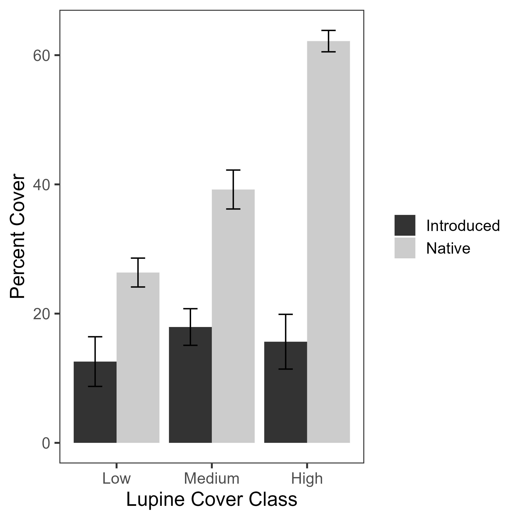
Native plant association with Lupinus rivularis on coarse sediments following dam removal; Elwha River, Washington - Karson Nicpon, Joey Lane, Bruce Cudkowicz, John McLaughlin
Facilitating native revegetation is important in restoration following dam removal, which exposes large areas of bare sediment vulnerable to invasion by exotic species. Coarse sediments in drained reservoirs provide a hostile growth substrate due to low moisture retention, low nutrient concentrations, low organic matter, and exposure to wind and intense sun. Revegetation on the Mills Reservoir bed, the largest restoration site in the Elwha River dam removal project, included seeding of riverbank lupine (Lupinus rivularis) to ameliorate harsh sediment conditions and facilitate succession. We assessed relationships between L. rivularis and other plants. We measured cover of native and introduced plants in coarse sediment plots stratified by three levels of L. rivularis density. We quantified relationships between lupine density and plant cover using a linear mixed model with sampling areas treated as a random factor. We evaluated relationships with species richness using a Kruskal-Wallis test. Our results revealed positive associations between L. rivularis and native species but not introduced species. The mechanism for these results needs further study, particularly determining whether the relationships are correlative or causal. Regardless of the mechanism, seeding with native nitrogen-fixing species could have broad application as dam removal projects increase in coming decades and revegetation of former reservoirs becomes a pervasive challenge.
The complete pre-print version of this article is available here.
Figure 2, below, shows increased cover of native plants with increasing lupine cover class, but not so for cover of introduced species.
Quaking aspen clonal expansion in the Greater Yellowstone Ecosystem - Hunter H. Holcomb, Autumn L. Keller, Dan Tyers, Daniel Z. Atwater
Quaking aspen is a widely distributed tree that provides valuable ecosystem services in Western landscapes, including forage for ungulates. It forms multi-shoot clones that can cover large areas and live for centuries. Although individual shoots die back, stands are maintained through asexual reproduction. Current threats include drought, ungulate browsing, and conifer competition. Owing to its ecological importance and sensitivity to disturbance, aspen has been the subject of a 34-year monitoring effort in the Custer-Gallatin National Forest in the Greater Yellowstone Ecosystem. To assess aspen status on this landscape, we used remote sensing to monitor changes in stand area from 1990–2023 and related the increase in 60 % of the stands to long-term changes in stand size-class composition, browsing, and conifer encroachment. Stand area in 2023 was associated with more intermediate-sized shoots and absence of encroaching conifers 18 years prior. Larger stands also tended to have more mature trees and experience less contemporaneous browsing. However, higher past browsing was associated with larger and faster-growing stands, indicating that browsing may have complex and conditional effects on aspen stand growth. Other site factors including slope, aspect, and elevation did not have detectable effects. Our results suggest that management promoting intermediate size classes and removing conifer competition could be important for the long-term health of aspen. Browsing affected stand area and structure but was not necessarily harmful. We hypothesize that intermediate browsing that stimulates suckering may be beneficial, provided it does not prevent regeneration of the mid-sized shoots that appear vital for long-term stand health.
The complete pre-print version of this article is available here.
Northwest Science 98(4)
Environmental DNA sampling identifies different nonnative and native salmonid species assemblages in two eastern Oregon wilderness areas - Ben C. Wiley, Kellie J. Carim, Kathleen G. O’Malley
Wilderness areas often provide critical habitat for native fishes. However, remoteness of wilderness areas can limit fish monitoring efforts, such that changes in nonnative and native fish distributions may not be detected and management responses may be delayed. Environmental DNA (eDNA) sampling offers a non-invasive and efficient method to monitor aquatic species across remote waterways. We used eDNA sampling and species-specific qPCR analysis to assess distributions of nonnative brook trout (Salvelinus fontinalis) and native bull trout (S. confluentus) and Columbia River redband trout (Oncorhynchus mykiss gairdneri) across sections of Monument Rock and Strawberry Mountain Wilderness Areas in eastern Oregon. In Monument Rock, we did not detect brook trout or bull trout eDNA, supporting previous findings of brook trout non-invasion and bull trout extirpation. Redband trout eDNA was detected at 29 of 34 sites despite recent environmental disturbances. Environmental DNA from all species was detected in Strawberry Mountain. Brook trout eDNA was detected at 10 of 17 sites, indicating upstream expansion of this nonnative species in Meadow Fork Big Creek. Bull trout eDNA was detected at seven sites and redband trout eDNA was detected at four sites, confirming native salmonid persistence despite decades of co-occurrence with brook trout. Brook trout eDNA concentrations were highest in samples closer to High Lake where the species was first introduced, while native salmonid eDNA concentrations were higher at locations further from the lake. This study provides baseline distributions for these species and a framework for using eDNA sampling to monitor fish distributions in remote areas.
Western oak mistletoe (Phoradendron villosum subsp. villosum) on non-native urban trees of western Oregon - David C. Shaw, Max Bennett, Don Goheen, Alan Kanaskie, Scott Altenhoff
Western oak mistletoe (Phoradendron villosum subsp. villosum) (WOM) occurs on native oaks (Quercus spp., Fagaceae) from Baja California, Mexico to the northern Willamette Valley, Oregon, USA. A variety of other native and non-native hardwoods within its native range are also hosts. We used the diverse urban forests of western Oregon (Salem, Corvallis, Eugene, Medford, Central Point, Rogue River, and Ashland) as a natural laboratory to investigate the host range of WOM and to assess the effects of WOM on tree health. During the leaf-off period of deciduous hardwood trees, we surveyed these urban forests for the occurrence of WOM in crowns of non-native trees. We collected data on tree species, tree size, height, mistletoe abundance, and tree condition. We observed WOM in 227 non-native trees, of which 85 percent were pin oak (Q. palustris) or northern red oak (Q. rubra), 12 percent were other oak species, and only 3 percent were individuals of non-oak species, despite the fact that non-oak genera represented from 81 to 96 percent of the urban trees in four cities with tree inventories. WOM tended to occur in larger trees which is consistent with the literature. We found no observable effects of mistletoe infestation on tree condition. The decision to manage WOM should involve oaks only, and depends on whether tree owners are concerned about potential negative effects of heavy infestations on tree health or desire increased biodiversity. Urban forest managers could also consider alternatives to red oak group species if WOM is abundant in the area.
The complete pre-print version of this article is available here.
Ecological, demographic, and physical characteristics of Sierra Nevada red foxes in the Oregon Cascades - Jamie L. Bowles, Corey Heath, Tim L. Hiller
Little is known about the montane subspecies, Sierra Nevada red fox Vulpes vulpes necator (SNRF). The SNRF is a habitat specialist putatively limited to sky islands of alpine and subalpine meadows and parklands in the Cascades of Oregon and California, and the Sierra Nevada of California. Populations in California have experienced substantial range contractions for unknown reasons in recent decades, complicating research and management, whereas populations in Oregon are more widespread, thereby allowing for accumulation of basic knowledge with conservation and management benefits. We collected data on radiomarked SNRF in Oregon during 2016–2020. Using a biased random bridge approach, SNRF showed patterns of larger areas used during the breeding (e.g., 95% utilization distribution, x̄ = 138.3 km2; n = 10) vs. nonbreeding (x̄ = 79.5 km2; n = 12) season. Based on selection ratios to assess second-order cover selection, SNRF most strongly selected for parkland and meadow (alpine and subalpine), woodland (alpine and subalpine), grassland (alpine and subalpine), forest (hemlock dominated), and rock (volcanic, other), regardless of season. For third-order selection, SNRF often strongly selected for developed land-cover types, potentially associated with anthropogenic food sources. The most common cause of mortality was potential predation (3 of 7 foxes), and mean annual survival probability was 0.69. Given that SNRF are generally limited to sensitive, linear-shaped alpine and subalpine areas primarily on federal lands, multi-agency coordination for management decisions are necessary to address or mitigate impacts from humans, including impacts from increasing levels of recreational use and development.